

AquaScape is the world's largest geospatial database of aquaculture operations. It maps land-based and offshore farms at scale, from regional distribution to individual site polygons, and provides the intelligence layer that public bodies, certifiers, feed mills, and investors use to make decisions grounded in verified data.
- Public sector
- Certifiers
- Feed mills
- Investors
Public sector
Regulatory decisions about aquaculture licensing, spatial planning, and environmental policy depend on knowing what exists and where. AquaScape gives governments and regulators a verified, continuously updated map of aquaculture activity across their jurisdictions.
That visibility extends beyond individual sites. Regional distribution patterns, farm density, and proximity to protected areas are all accessible within a single platform. Planning decisions that once required extensive desk research can be grounded in validated spatial data from the outset.
For agencies managing multiple licensing processes simultaneously, AquaScape provides the shared baseline that makes coordination across departments and jurisdictions tractable.
Certifiers
Certification at scale requires knowing which farms exist, where they operate, and whether the geographic information they provide is accurate. AquaScape gives certification bodies a validated registry to work from, replacing reliance on self-reported farm lists with independently verified spatial data.
Site polygons confirm operational boundaries. Farm locations can be cross-referenced against environmental designations, exclusion zones, and existing certificates. Gaps and discrepancies surface early, rather than during audit.
For certification bodies operating across multiple standards and geographies, the shared data layer reduces the overhead of rebuilding farm registers for each programme.
Feed mills
Feed procurement and distribution planning depend on knowing where production is concentrated and how it is changing. AquaScape gives feed manufacturers a geographic view of aquaculture activity across their markets, mapped to the farm level.
Species distribution, farm scale, and operational status can be assessed across regions without relying on trade estimates or industry surveys alone. Where new production capacity is coming online, AquaScape identifies it before it appears in official statistics.
The result is a market intelligence layer that grounds commercial planning in verified spatial data.
Investors
Aquaculture investment decisions require a clear picture of where production exists, at what scale, and under what regulatory and environmental conditions. AquaScape provides that picture, mapped to individual farm polygons and enriched with environmental and operational context.
Screening a market or identifying assets in a specific geography becomes a structured process rather than a research project. Regulatory exposure, protected area proximity, and farm density can all be assessed before any direct engagement begins.
For portfolio monitoring, the same platform tracks what is changing across held assets, without requiring repeated data requests from operators.
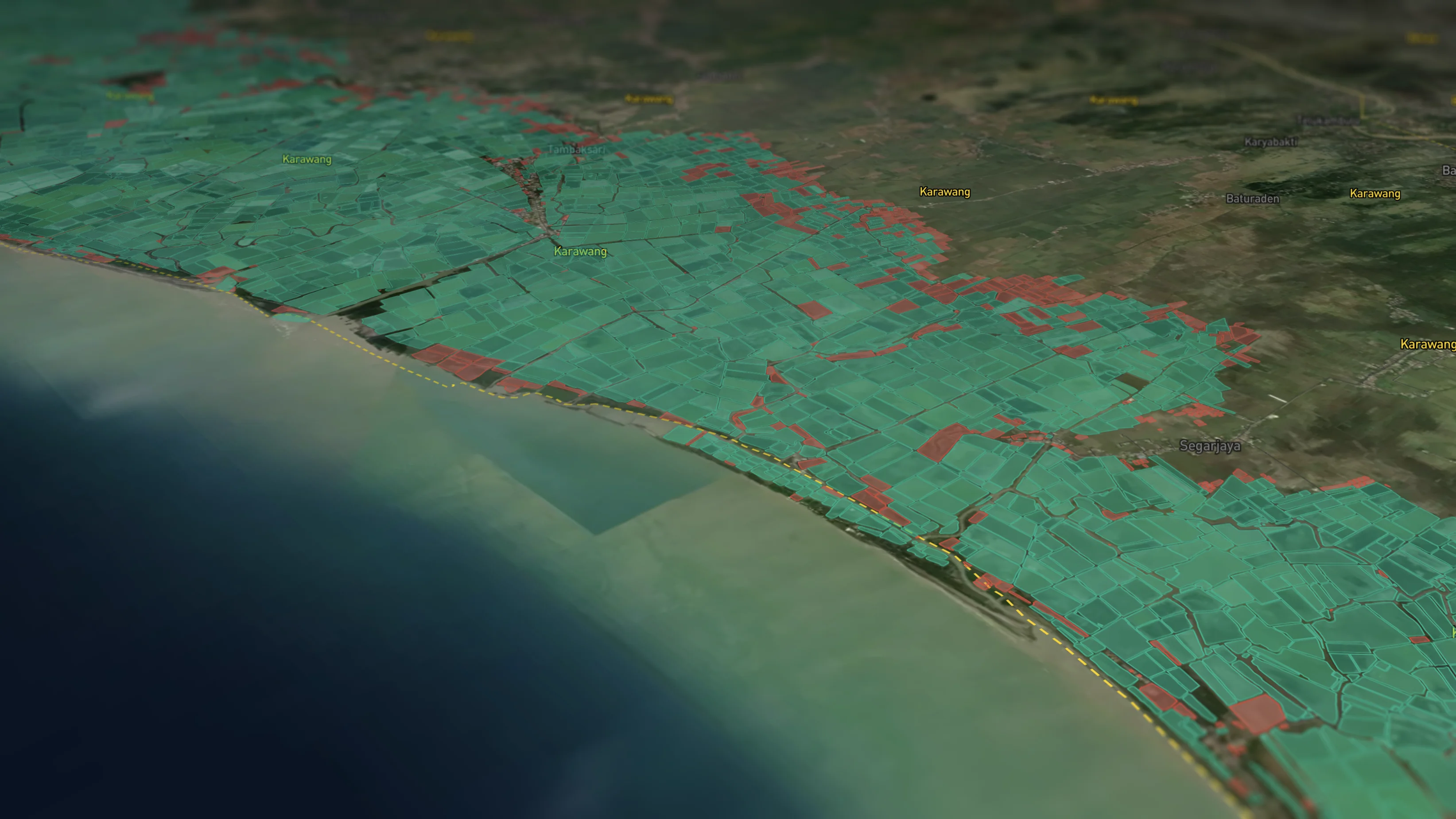
The most comprehensive validated database of aquaculture sites in existence.
AquaScape maps farm polygons with spatial precision across land-based and offshore environments, covering freshwater, coastal, and open-ocean operations at the individual site level. The registry provides the verified geographic baseline that every downstream analysis depends on.
Every variable. One architecture.
A flexible data architecture allows environmental, social, and production metrics to be combined and interrogated at any scale. Last-mile data collection closes the gap between what is reported and what is verifiable, enabling analysis that reflects operational reality rather than approximation.
Intelligence that holds at every scale.
Navigate from global farm distribution to individual site detail within a single platform. The intelligence layer maintains resolution and analytical integrity at every zoom level, from national spatial planning to site-specific verification and audit support.
Let's work together
Ready to transform your aquaculture operations with data-driven intelligence? Get in touch with our team.
- Farming
- Insurance
- Finance
- Governments & Regulators
- Certification
- Supply chain
- Conservation & NGOs
Know your farm. Know your risk.
Aquaculture operations face growing pressure to improve risk profiles to investors, regulators and buyers alike. Longline brings geospatial intelligence to risk management, environmental footprints and due diligence, giving farming businesses the clarity to operate with confidence and evidence to back it up.
Price what you can see. Trust what you can verify.
Insuring aquatic risk without reliable intelligence is guesswork. Longline gives insurers the geospatial tools to assess exposure, verify operations and support underwriting decisions grounded in data, not assumptions.
Lend and invest with your eyes open.
Whether you're structuring debt or deploying equity, operational due diligence in aquatic industries demands more than a site visit. Longline provides the geospatial intelligence to audit operations, assess risk and support financing decisions with the evidence they require.
The impact is only as good as the data behind it.
From carrying capacity assessments to licensing and environmental oversight, effective aquatic governance depends on being able to see clearly. Longline provides governments and regulators with geospatial intelligence to make policy decisions that are evidence-based, defensible, and built for the long term.
Scale your standards. Don't compromise them.
Certification bodies face a growing challenge: how to maintain rigour as the industries they serve expand. Longline provides the digital infrastructure and geospatial tools to scale certification processes, drive innovation and ensure standards hold up at any volume.
You can't assure what you can't trace.
Buyers, retailers and sourcing teams are under increasing pressure to demonstrate where their product comes from and how it was produced. Longline brings geospatial intelligence to chain-of-custody assurance, traceability, and impact measurement, so every link in the chain can be verified.
Good intentions need good domain knowledge.
Conservation outcomes depend on being able to measure what's changing, where and why. Longline works with NGOs and conservation bodies to deliver data-led impact assessments, support jurisdictional approaches and bring geospatial intelligence to the places where development innovation matters most.